Plimmerton Farm: getting greenfields right
If we’re determined to do more residential development in greenfields, what does “decent” look like in Plimmerton, hilly land near an existing suburb – like most of our region’s greenfields?
This post is basically to help anyone who’s time-poor but cares about Plimmerton, good urban development, or healthy wetlands, streams and coast.
It’s compiled from talking with several professionals in planning, urban design, transport planning and architecture, and from other smart nerdy people who’ve done epic submissions. (see Extra Submissions below, for more info.)
They have gone through the truckloads of documents Porirua City Council have stuck up without any decent meta-guidance, so you don’t have to!
In this post you’ll find some contextual guff about why I think it’s worth submitting, then the nuts and bolts of what the council needs to hear, arranged in a basic “Situation + what needs to change” pattern.
Have a read of what I’m submitting and why.
Then if you generally agree with the thrust, you’ll find in “Submission tips” some hints and – for the very time-poor – a handy pre-filled submission document! Easy peasy.
The background: what where and how
For those who don’t know…
- Plimmerton Farm’s a big proposed residential-subdivision of hilly farmland draining into the significant Taupō Wetland and to Plimmerton Beach, just over the train line and highway from Plimmerton village (original Ngāti Toa name: Taupō).
- It’s going through a Streamlined Planning Process, a pre-COVID government scheme for accelerating development.
- The key step is the requisite change of the land’s zoning in the Porirua District Plan (“rural” zone to “residential” and other “urban” zones) that sets out what kind of stuff can then be built, where.
- It’s mostly streamlined because there’s just one shot for the public to have input on the plan change. One shot.
Why submit?
Well here’s why I am…
I was born and raised in Plimmerton, live here now, and intend to for the rest of my days. I’d love to see it grow, well. I would love Plimmerton to get more wallets, more hearts and minds, more faces (more diverse ones too!). But not with the stuff that comes with poor-quality development: more traffic, and pointless damage to our environment.
Right now, the proposal has some serious flaws which need sorting. I say Sorting because the changes won’t make it crazy innovative and cutting-edge, just good enough for a development in the spot it is, being kicked off in 2020.
Time matters too: there’a a bunch of good things happening imminently (and some bad Porirua trends that need to be reversed). I cover these in Get it right, below.
It’s worth submitting because given the situation, a 1990s-grade development just won’t cut it.

So what about Plimmerton Farm needs to change?
It boils down to two themes:
- dial down the driveability and dial up the liveability
- make Local the logical and easy choice for daily needs
I’ll outline what needs to change in each.
NOTE: There’s a third – don’t stuff the wetlands and streams.
This is really important as Taupō Wetland is regionally significant, and all our streams and harbours have suffered from frankly shameful mismanagement of sediment from earthworks-heavy subdivisions like Aotea and Duck Creek, and from the earthworks-a-rama of Transmission Gully. Friends of Taupo Swamp have an excellent submission guide for you – add in some of their suggested bits to your submission.
I: Dial down the driveability, dial up the liveability
There aren’t many truly black-and-white things in life, but there’s one for towns:
If a street is nice to drive in, it’ll be a crappy place to do anything else in – like walk / eat / hang out / have a conversation / play / scoot or cycle / shop / have a pint. It’ll suppress what you can do with the land either side of the bit the cars go on – i.e. the land that matters.
If it’s nice to do anything else in, it’ll be a crappy place to drive in. When driving, you’ll feel the environment is seriously cramping your style! You’ll be alert, poised to brake often, you’ll go slower than you might like, because it’s highly likely something or someone might come out into the road – a nanna crossing! A kid playing! Some women chatting! A guy visiting his mates! This will be a far cry from the blissful soundtracked experience the car companies show us in the TV ads.
There’s screeds of evidence worldwide demonstrating the black-and-white phenomenon, but if we think for a moment about why it makes sense. Mostly it’s inherent to the nature of automobiles:
- big solid things that smash into our bodies if someone makes a mistake (75% odds of death if that’s at 50km/hour, 30% odds of death if at 30km/hour)
- big objects that need lots of space for manoeuvering and especially parking – offstreet, making homes crazy expensive and onstreet, locking up valuable public space
- big solid things driven by us real humans (for a while at least) who respond to the environment but also get distracted, and generally aren’t great at navigating them without killing each other.
The transport setup proposed for Plimmerton Farm is geared the wrong way. It’s much too driveable, which means it’ll be poorly liveable.

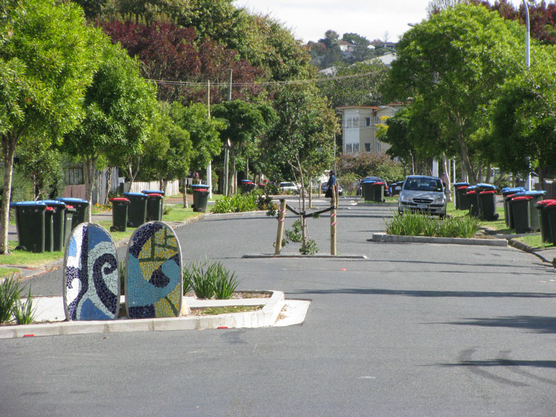
1. Narrow down all the roads.
The current proposal’s roading setup has roads and streets that are too big, and there’s too much of them.
Right sized roads for a liveable community
The cross-sections for the roads include on-street parking and really wide lane widths.
This is really gobsmacking for a consortium that talked a big talk about good practice. For all the reasons that Low Traffic Neighbourhoods are good, this is bad.
(And it’s especially nuts when you realise that the excessively wide “arterial” roads (11 metres!) will need earthworked platforms built for them where they’re drawn running up the sharp ridges and across the tops of gullies. Expensive, damaging for the environment, and … what were they thinking?)
So recommended changes:
DIAL BACK THE ROADS. Seriously. Design all the living-area streets and roads, and the centre, to be self-explaining for an operating traffic speed of 30km or less – that’s the speed where mistakes are rarely fatal.
What does that look like? The designers will know and if they don’t they should be fired; it’s not up to us to tell them how to do their jobs. But for your curiosity here’s a whistle-stop tour of the things designers can choose from to make Plimmerton Farm roads and streets liveable and people-friendly:
- MUCH narrower crossing distances at intersections for people walking
- Chicanes – ideally with green stormwater infrastructure, trees and seating
- Narrowed sight-lines (trees! sculpture!) which help make the road self-explaining
- Narrower trafficked lanes (which will be helped by rori iti on the larger roads!), with properly wide and friendly footpaths
- Threshold treatments, modal filters, so on and so on – all the stuff you’ll see in NZTA’s neighbourhood greenways info
All the things we know very well are the natural ways to slow us down when driving, and make streets nicer for people.
The beauty of all this “restriction” on driving is how much it frees us up for making everything else appealing.
Streets become healthy streets: hospitable for kids to walk, scoot, bike to school safely, using the road not the footpath. Older people and those with impairments can walk and wheelchair safely. Teens coming home from town of an evening can scoot or bike home, safely. Popping down to the shops or for a coffee or to the train becomes a pleasure to do on foot, or on a scooter or bike.
And when getting around this way you’re moving in a legitimate way – seeing and being seen, not stuck off in the bush on a recreational track (the only meaningful cycling provision they’ve described), or being made to huddle in a little “pedestrian cage” in the middle of some over-built road. No, with healthy streets the ordinary streets and roads are walkable, bikeable, scootable, mobility-scootable, and perfectly driveable, equally safe and useable in all weathers and anytime of day or night, for people of all ages.
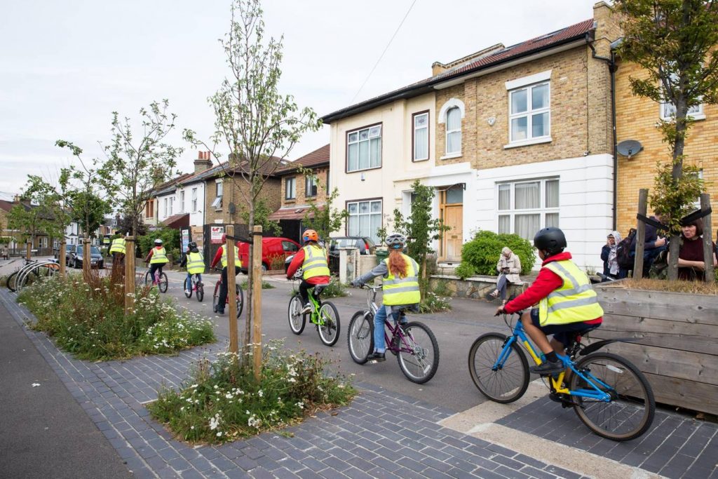
(And in case you’re worried about firetrucks / rubbish trucks / buses, recall that on even Wellington City’s far more winding, narrower hilly streets everyone gets their rubbish collected and fires fought just fine. For public transport, smaller buses (like those that community transport operators already use), are the way of the future for less densely-populated areas like this).
So, submission points:
Design all the precinct streets and roads, and the centre, to be self-explaining for an operating traffic speed of 30km or less with extensive threshold treatments and traffic calming, significant focus on amenity and walkability, and green infrastructure
Reduce the carriageway widths of the three collector type roads, including adding in separated protected biking and scooting infrastructure
Generally scale down the roads throughout the development to lower in the road hierarchy.
2. Don’t build the through and loop roads.
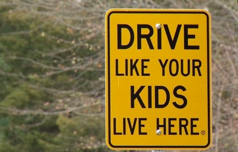
You don’t need signs like this when the only people who bother to drive in are those who live there, or who are visiting friends, because you just have to drive out again the way you came.
When it’s the place you live, you’re invested in not being a dick far more than if you’re just out for a drive – or worse, out for a bit of a boyrace hoon on a massive loop route through a whole place. We know the story: residents start complaining of boyracers hooning through their quiet suburb. After a few people’s pets are killed (hopefully not a person), council eventually retrofits (expensively) some ugly speed humps.
So just don’t build those big connector roads that enable people to drive easily from one residential area to the next, especially the ones up in the hilltops (section C) that just say “come for a hoon!” Instead, connect the living spaces thoroughly for people: bikeable, walkable, scootable, disability-friendly streets and lanes. As much as possible, only one way in and out for cars from each living area.
Submission point:
Don’t build for driving between precincts (the giant loops). Connect precincts only with neighbourhood scale streets – walkable / bikeable / scootable neighbourhood greenways.
II: Make local logical and easy
Plimmerton is a true village, with a great little centre (including a train station!) but Plimmerton Farm is ultimately a damn big area. The way to go is to enable people to get the basics of life – like school, groceries, a coffee – with a little local trip on foot, bike or scooter – it’s more of a bother to get in the car. Right now though, it needs two changes:
1. Provide for a second centre
“Bumping into” spaces are known to be crucial to a feeling of neighbourhood, and in the (initial) absence of third places (worship places, community hall, sports club, cafe/pub, a supermarket is a vital social centre. Yet the north end of Plimmerton Farm is currently a deadzone for anything except residential.

Like in Edwards Scissorhands without the castle.
There’s no provision for a place to do your household groceries, so people will drive to Mana New World – more car trips – and less opportunity to bump into people who live nearby.
(A note on schools as a community bumping space: there’ll be no school in Plimmerton Farm for a while, because the Ministry of Education isn’t allowed to build a school somewhere until there’s a certain population density of kids to fill it. It’s a shitty Catch-22 for towns trying to do good development, and hopefully will be fixed in the law … sometime.
Just another reason to make Plimmerton Farm’s streets really kid-friendly for them to walk, bike and scoot: extra dropoff traffic for kids going to St Theresa’s, Plimmerton, Paremata and Pukerua Bay schools will be a nightmare.)
…but no centre should have big-box retail.
One thing to watch out for: in the existing proposal it’s possible to have big-box retail in the Plimmerton Farm centre. Not just small awesome locally-owned businesses that you could put shop-top housing on, nope: a ginormous barn of a Bunnings or Warehouse à la the Porirua Megacentre, with acres of parking lot, generating loads of traffic, pouring contaminated stormwater runoff into the stream (cos they’ve already said they’re not going to bother treating that). If that wasn’t enough, big-box would also lock up acres of valuable space in the village centre, in walking distance from a train station – the highest value land! Just no.
So submission points:
Provide for an additional neighbourhood-focussed centre in the northern part of Plimmerton Farm, including a groceries place of some kind.
Big-box retail should be a non-complying activity in Plimmerton Farm.
Also, the “commercial” centre is right on some crazy topography – gullies they’ll be earthworking the bejeebiz out of to make buildable platforms. Just another reason to use the Friends of Taupō Swamp guidance to add to your submission too!
2. Intensify within walking distance of Plimmerton proper.
We should intensify properly, with lots of medium density (maximum 5 storeys of nicely laid-out density done well – up to 60% site coverage) in the area that’s within a 5-minute walk of Plimmerton Village. The more people can live and work with access to all its many amenities, and its rail station (10 min to Porirua, 30 min to Wellington), the better. But there’s not enough density provided for there in the proposal.
What could that higher density look like? Nice, and shorter than you’d think. A good example is 3333 Main, Vancouver .

So submission point:
Add another zone – E – of higher density in that 5-minute walking catchment of Plimmerton Village, as per the map in the Talk Wellington post.

(Tip: they’ll know about this post, so you don’t have to worry about describing the map in words!)
Submission tips
On the site they ask you to fill in a Word or PDF form, saying which specific bit of the gazillion proposals you are talking about and the specific changes you want. This is, frankly, a BS way to treat the vast majority of people submitting: normal non-professionals, just regular people who care about good development and liveable places.
So just don’t worry about that.
In those question 6 column boxes just put “Transport” and “Layout”. It’s the professional planners’ job to figure out specifically how to change a planning document. Just be specific enough that they know what you want to see. The above “submission points” are worth copying and pasting – that’ll be enough.
Are you really time-poor? Just download ’em pre-filled in for your convenience. [57KB Word]
And don’t forget the Friends of Taupo Swamp and Catchment advice is essential – definitely go read and use.
That’s all you really need – just go submit!
But if you’re keen to know more reasons why they should be doing this better, here’s some…
Get it right, now
Once this plan change is through, traditional developers like Gillies like to whack in all the infrastructure – hello, massive earthworks. And yet the place will take decades to fill with actual people – those hearts and minds and wallets.
(Note even before COVID, BERL forecasted Porirua’s medium-projection growth rate [PDF519KB] as 0.4% per year (high was 0.9%, low was -0.2%). Yep, even the high projection of our population growth, pre-COVID, is less than one percent growth per year!)
And extra pressure’s on to do this better because all these things are features of the next one to three years:
- the One Network Road Classification (sets the design specs for roads of different types) is being updated right now to be more people-friendly in the specs for roads in residential and centre areas, so designs like Plimmerton Farm’s current roads will soon be Officially Bad Practice
- Sales and riding of e-bikes and e-scooters are going through the roof, continuing through and beyond COVID – this shows no signs of slowing, and prices are dropping. E-power flattens the hills of Plimmerton Farm and makes wheely active travel a breeze for the middle-class people who’ll be living here, if the streets and roads are hospitable
- Plimmerton Railway Station (on the most popular Wellington train line) is being upgraded to be a terminus station – i.e. better services
- The Wellington Regional Growth Framework is setting a bunch of directions for councils on how to grow well, including well-known but often well-ignored issues like intensifying around public transport hubs
- Councils will soon be required to do to a bunch of a bunch of international good practice that Plimmerton Farm isn’t doing right, including getting rid of minimum parking requirements (in the news lately), and upzoning (enable intensification) of landuse in the walking catchment of public transport hubs. (5 min walk = approx 400 metres, 10 min = 800m).
- Bad trends we need to stop: Porirua’s really high car-dependency (we own cars a lot and drive a lot) is continuing, due to car-dependent urban form [PDF]– despite nice words in council’s strategic intentions.
- People living outside Wellington City are mostly to blame for our region’s 14% increase in emissions from transport in just 10 years.
OK go submit now – and share this post with anyone who you think might care!
Extra submission info:
- A summary of the stuff I’ll be putting in [5.3 MB PDF]– thanks to Holistic Urban Environments for the pro bono work!
- A great summary focusing on the visual effects of Plimmerton Farm [602K PDF], done by Trevor Beamsley of Pōneke (a Plimmertonian). Also the source of our banner image for this post!
- Personal submission [497 KB] by Karla and Trevor Beamsley of Plimmerton
I support everything you wrote about this development.
In my reading through the sections about water and the environment, the effect on the Taupo Swamp and the local fauna, the outcomes look grim. I cannot see that the sophisticated measures recommended will happen. Fast tracking this proposal seems foolish and possibly disastrous. When you still see the silt pouring into the harbour from Whitby, you realise that these developments are never effectively policed. I see that the deadline has come and gone, but, I do so thank you for the work you have done.
Cheers Lila, leaning on councillors is always good so emailing them about this with your views will be useful anytime!
This is a brilliant work-through of what a new subdivision could look like. Namely, a human-sized human-welcoming environment that treats cars as tools for reasonable use instead of the dominant masters of the landscape. We don’t want developments that look like Whitby and the new area opposite Papakowhai that are sterile and have little or no services or community hubs. Not to mention the lack of care towards the natural needs of the land – drainage, wetlands and massive environment-destroying earthworks. The pictures showing human presence, not metal car presence, say it all. The 15-minute rule (everything you need is 15 minutes walk or less away) is a sound rule of thumb to make subdivisions humanly livable.